Multi-scale interactive maps such as Google Maps or OpenStreetMap have replaced paper topographic maps for most professional and daily uses. Past research told us how to design paper topographic maps at a given scale to make them readable and understandable by human users. But these rules/guidelines do not apply anymore, and map designers lack guidelines to make maps that are smooth to explore through scales, and it is common for a multi-scale map user to feel lost for a few seconds after a zooming interaction. The LostInZoom project (Not Getting Lost in Multi-Scale Maps: Exploring the Anchor Theory in Cartographic Zoom Interactions in the Context of Crisis Management) seeks to establish a new zooming paradigms for multi-scale maps, based on multi-scale visual landmarks that act as anchors during the zoom. To achieve this novel zooming paradigm, we need new grounding knowledge on how people perceive and understand interactive multi-scale maps, in order to design maps and interaction that make multi-scale explorations smoother. The LostInZoom project will be based on three main pillars. In the first one, we will explore the cognition of multi-scale interactive maps with an experimentation approach, in order to identify the anchors or landmarks that help a map reader locate himself when zooming. In the second pillar, we will design new cartographic generalisation techniques to derive multi-scale maps that magnify the landmarks that are important for multi-scale exploration. Finally, the third pillar will be dedicated to the design of new zooming interactions that focus on these landmarks to smooth even more the zooming exploration.
Funded by the European Union (ERC, LostInZoom, grant n°101003012). Views and opinions expressed are however those of the author(s) only and do not necessarily reflect those of the European Union or the European Research Council Executive Agency. Neither the European Union nor the granting authority can be held responsible for them.
 Guillaume TOUYA Senior researcher Drecteur de recherche |
 Justin BERLI GI Scientist Ingénieur géomaticien |
 Laura WENCLIK GI Scientist Ingénieure géomaticienne |
 Paul BOURCIER GI Scientist Ingénieur géomaticien |
 Azelle COURTIAL Post-doctoral fellow Post-Doctorante |
 Quentin POTIE PhD student Doctorant |
 Maïeul GRUGET PhD student Doctorant |
 Bérénice LE MAO PhD student Doctorante |
 Yiyan LI PhD student Doctorant |
 Ian MUEHLENHAUS University of Wisconsin-Madison University of Wisconsin-Madison |
 William MACKANESS Senior Lecturer - School of Geosciences, University of Edinburgh Senior Lecturer - Université d'Edimbourg |
• Bourcier, P., J. Berli, G. Touya. ‘CartAGen. Une bibliothèque Python et un plugin QGIS pour la généralisation cartographique'. Mappemonde (2025): 140.
• Touya, G., J. Berli., P. Bourcier ‘A three-in-one tool for cartographic generalization with the new version of CartAGen'. Advances in Cartography and GIScience of the ICA (2025): 5.
• Touya, G., A. Courtial, J. Kalsron, J. Berli., B. Le Mao, L. Wenclik ‘Understanding the Carbon Footprint of Tile Transfer for Web Maps'. ISPRS International Journal of Geo-Information (2025): 14(3).
• Gruget, M., G. Touya., I. Muehlenhaus ‘Quantifier la saillance et la persistance cartographique dans les cartes pan-scalaires'. Actes de SAGEO (2025).
• Le Mao, B., G. Touya ‘Vers un Maps 2.0 - Construire une carte pan-scalaire plus progressive'. Actes de SAGEO (2025).
• Wenclik, L., G. Touya ‘Regarde le toponyme ou la mer'. Actes de SAGEO (2025).
• Bourcier, P., G. Touya ‘The role of map generalisation in the context of thematic multi-scale cartography'. Proceedings of the ICA Workshop on Multiscale Cartography and Sustainability (2025), Vancouver, BC, Canada.
• Touya, G. ‘Back to the roots - Using map generalization for green cartography'. Proceedings of the ICA Workshop on Multiscale Cartography and Sustainability (2025), Vancouver, BC, Canada.
• Karsznia, I., I. Ajdacka, B. Le Mao, G. Touya, A. Adolf ‘Level of detail matters: machine learning based river selection across Polish and French data'. Proceedings of the ICA Workshop on Multiscale Cartography and Sustainability (2025), Vancouver, BC, Canada.
• Touya, G. ‘This is a map of ‘Jardin Lecoq’ - Analyzing map descriptions from LLMs'. Proceedings of 2nd CartoAI Workshop (2025), Dresden, Germany.
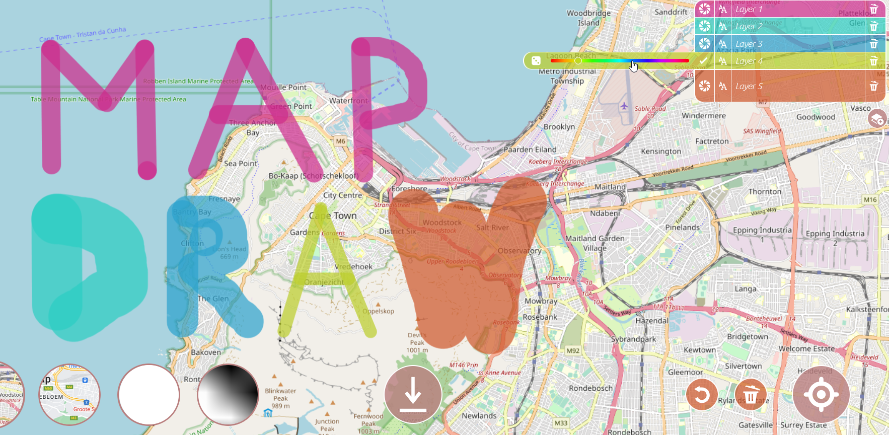
• Berli, J., G. Touya., M. Gruget, Q. Potié ‘MapDraw. Un outil libre d’annotation de cartes en ligne'. Mappemonde (2024): 138.
• Gruget, M., G. Touya., I. Muehlenhaus ‘Exploring the presence and persistence of cartographic anchors in pan-scalar maps'. Spatial Cognition & Computation (2024).
• Gruget, M., G. Touya., Q. Potié, I. Muehlenhaus ‘A methodological inquiry for anchoring pan-scalar maps'. AGILE: GIScience Series 5 (2024): 27.
• Wenclik, L., G. Touya ‘EyeCatchingMaps, a Dataset to Assess Saliency Models on Maps'. AGILE: GIScience Series 5 (2024): 51.
• Le Mao, B., G. Touya ‘Explore maps as you read a comic book'. AGILE: GIScience Series 5 (2024): 10.
• Courtial, A., G. Touya. ‘Strategies for pan-scalar map generalisation'. Abstracts of the ICA 7 (2024): 25.
• Le Mao, B., I. Ajdacka, I. Karsznia, G. Touya, A. Adolf. ‘Enriching river network data for multi-scale machine learning based selection: a case study of Poland and France'. Abstracts of the ICA 7 (2024): 83.
• Li, Y., G. Touya. ‘Exploring new ways to zoom in maps'. Abstracts of the ICA 7 (2024): 86.
• Potié, Q., G. Touya. ‘Browsing Map Browsers'. Abstracts of the ICA 7 (2024): 130.
• Touya, G., R. Brusq, L. Campo, V. Pech, L. Wenclik. ‘Recording the Use of Interactive Web Maps with ZoomTracker'. Abstracts of the ICA 7 (2024): 176.
• Wenclik, L., G. Touya. ‘Where do people look at during multi-scale map tasks?'. AGILE: GIScience Series 4 (2023): 51.
• Touya, Guillaume, Quentin Potié, William A. Mackaness. ‘Incorporating Ideas of Structure and Meaning in Interactive Multi Scale Mapping Environments'. International Journal of Cartography 9, nᵒ 2 (2023): 342‑72.
• Touya, Guillaume, Justin Berli, Maïeul Gruget, Quentin Potié. ‘MapDraw - an online tool to draw anything you want on top of a map'. In Proceedings of AGILE 2023 - Poster session. Delft, The Netherlands, 2023.
• Touya, Guillaume, Justin Berli, Azelle Courtial. ‘Cartagen4py, an open source Python library for map generalisation'. In Proceedings of 25th ICA Workshop on Map Generalisation and Multiple Representation. Delft, Netherlands, 2023.
• Touya, Guillaume, Justin Berli. ‘The FogDetector: A User Survey to Measure Disorientation in Pan-Scalar Maps'. In 12th International Conference on Geographic Information Science (GIScience 2023), édité par Roger Beecham, Jed A. Long, Dianna Smith, Qunshan Zhao, et Sarah Wise, 277:73:1-73:6. Leibniz International Proceedings in Informatics (LIPIcs). Dagstuhl, Germany: Schloss Dagstuhl – Leibniz-Zentrum für Informatik, 2023.
• Potié, Quentin, Guillaume Touya, William Mackaness. ‘Experiments in the automatic segmentation of anchors using deep learning techniques'. In Proceedings of the 1st CartoAI Workshop. Leeds, UK, 2023.
• Le Mao, Bérénice, Guillaume Touya. ‘Progressive river network selection for pan-scalar maps'. In Proceedings of 25th ICA Workshop on Map Generalisation and Multiple Representation. Delft, The Netherlands, 2023.
• Lafon, Eric, Quentin Potié, Guillaume Touya. ‘Salient building detection using multimodal deep learning'. In Proceedings of the 1st CartoAI Workshop. Leeds, UK, 2023.
• Dumont, Marion, Guillaume Touya, Cécile Duchêne. ‘More is less - Adding zoom levels in multi-scale maps to reduce the need for zooming interactions'. Journal of Spatial Information Science 27 (2023).
• Courtial, Azelle, Guillaume Touya. ‘Does Generalisation Matters in Pan-Scalar Maps?'. In 12th International Conference on Geographic Information Science (GIScience 2023), édité par Roger Beecham, Jed A. Long, Dianna Smith, Qunshan Zhao, et Sarah Wise, 277:23:1-23:6. Leibniz International Proceedings in Informatics (LIPIcs). Dagstuhl, Germany: Schloss Dagstuhl – Leibniz-Zentrum für Informatik, 2023.
• Courtial, Azelle, Jérémy Kalsron, Bérénice Le Mao, Quentin Potié, Guillaume Touya, Laura Wenclik. ‘Text-to-map generation: a review of current potentials'. In Proceedings of the 1st CartoAI Workshop. Leeds, UK, 2023.
• Gruget, Maïeul, Guillaume Touya, Ian Muehlenhaus. ‘Missing the city for buildings? A critical review of pan-scalar map generalization and design in contemporary zoomable maps'. International Journal of Cartography (2023): 1‑31.
• Touya, Guillaume, Maïeul Gruget, Ian Muehlenhaus. ‘Where Am I Now? Modelling Disorientation in Pan-Scalar Maps'. ISPRS International Journal of Geo-Information 12 (2) (2023): 62.
• Potié, Quentin, Chaimaa Beladraoui, Amina El-Moutaouakkil, Guillaume Touya, William A. Mackaness. ‘Deep learning for anchor detection in multi-scale maps'. In Proceedings of EuroCarto 2022, Abstracts of the ICA 5:82. Vienna, Austria: Copernicus Publications, 2022.
• Potié, Quentin, William A. Mackaness, et Guillaume Touya. ‘When is a Ring Road a ’Ring Road’? A Brief Perceptual Study'. In AGILE GIScience Series, 3:54. Vilnius, Lithuania: Copernicus Publications, 2022. https://doi.org/10.5194/agile-giss-3-54-2022.
• Touya, Guillaume. ‘L’Alpe d’Huez: A Benchmark for Topographic Map Generalisation'. Abstracts of the ICA 4 (2022): 1‑2. https://doi.org/10.5194/ica-abs-4-4-2022.
• Touya, Guillaume, Maria-Jesus Lobo, William A. Mackaness, et Ian Muehlenhaus. ‘Please, Help Me! I Am Lost in Zoom’. In Proceedings of the ICA, 4:107. Firenze, Italy: Copernicus Publications, 2021. https://doi.org/10.5194/ica-proc-4-107-2021.
A python open library for map generalisation, it is originally a port of the CartAGen Java platform
Une librairie Python pour la généralisation cartographique, il s'agit d'un portage de la plateforme Java CartAGen./p>
A Django project aims at providing a framework to develop scientific experiments on map navigation.
Un projet Django pour favoriser le developement d'experiences de navigation dans des cartes.

A serious game for smartphones to assess the skills of people in using pan-scalar maps.
Un jeu sérieux pour téléphone qui permet d'évaluer les compétences dans l'utilisation des cartes sur téléphone.
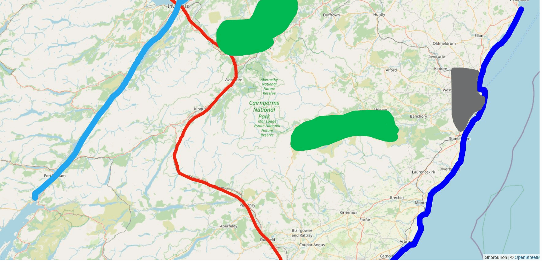
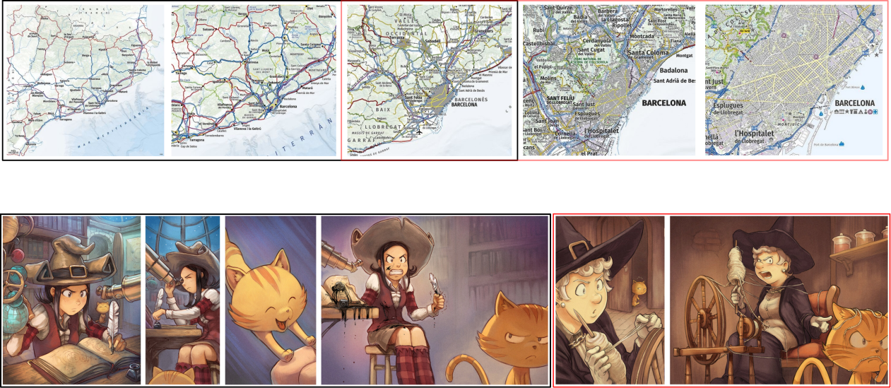
A multi-scale map showing the impact of an earthquake on people and buildings, to help civil protection professionals carry out rescue operations.
Une carte multi-échelles montrant les impacts d'un séisme sur les personnes et les bâtiments, afin d'aider les professionnels de la sécurité civile à mener à bien leurs opérations de sauvetage.
A map image dataset that aims to be used for benchmarking saliency detection in maps.
Un dataset d'images de cartes pouvant être utilisé comme benchmark pour la détection de saillance dans des cartes.
This dataset can be used to benchmark road selection algorithms. It contains two road networks, one used for 1:25k scale maps, and one used at the 1:80k scale.
Ce jeu de données peut être utilisé pour comparer des algorithmes de selection de réseaux routier. Il contient deux réseaux routiers, un pour la cartographie à grande échelle (1:25k) et un à moyenne échelle (1:80k).
This dataset is a benchmark for topographic map generalisation at 1:50k scale. It includes several topographic layers, a style description and generalisation constraints.
Ce jeu de donnée est un benchmark pour la généralisation de carte topographique à l'échelle 1:50k. Il inclut des couches de données topograhiques, des consignes de symbolisation et des contraintes de généralisation.
An image dataset representing how mountain road shape may be generalised that aims to be used for benchmarking graphic map generalisation.
Un dataset d'images de cartes représentant la généralisation de routes de montagne qui peut etre utilisé pour comparer des modèles de généralisation cartographique graphique.
This dataset contains the material of a user survey presented in the paper " More is Less - Adding Zoom Levels in Multi-Scale Maps to Reduce the Need for Zooming Interactions".
Ce jeu de donnée contient le matériel du test utilisateur présenté dans l'article " More is Less - Adding Zoom Levels in Multi-Scale Maps to Reduce the Need for Zooming Interactions".
This dataset is a collection of disorientation stories experienced using of a multi-scale topographic map, either on a phone or on a computer.
Ce jeu de donnée regroupe des histoire de désorientation pendant l'utilisation d'une carte topographique multi-échelle, sur un ordinateur ou un smartphone.
The FogDetector is a survey that aims to measure and better understand the desert fog effect occurring when we explore interactive pan-scalar maps.
L'enquête FogDetector mesure et explique l'effet FogDetector de désorientation pendant l'exploration d'une carte pan-scalaire.
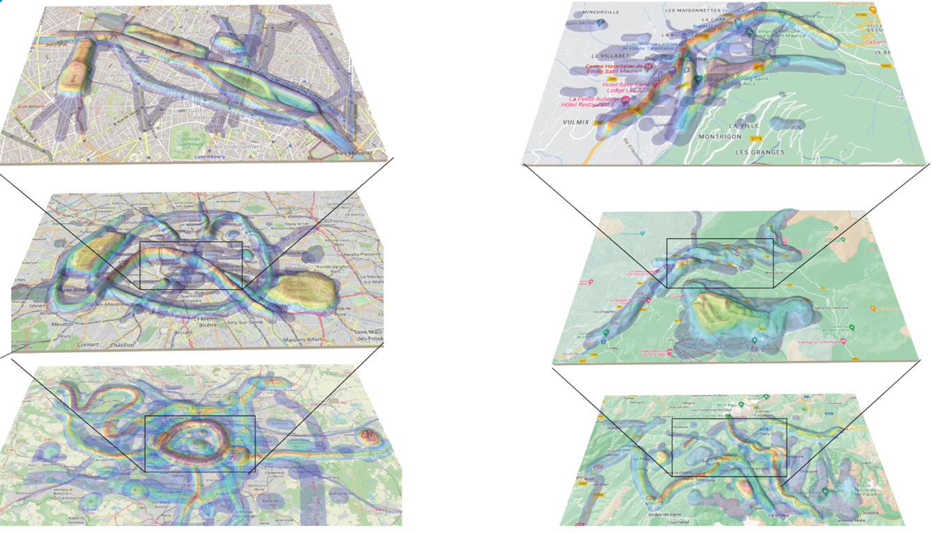
Eye tracker recording from a survey aims at understanding what a person looks at to find their way around a multi-scale map, and the different map exploration strategies.
Enregistrement des données occulométriques d'une expérience dont le but est de comprendre ce que les utilisateurs regardent pour se repérer dans une carte multi-échelle, et les différentes stratégies d'exploration de la carte.
Images and results from the survey presented in the paper "When is a Ring Road a 'Ring Road'?"
Image et résultats de l'enquête présentée dans le papier "When is a Ring Road a 'Ring Road'?"
Anchorwhat is a user study where participants were asked to draw memorable, salient landmarks they saw on the map. This dataset contains the data produced during this user study.
Ce jeu de donnée contient les données issues d'un test utilisateur laquelle il était demandé aux participants de dessiner des points de repère mémorables et saillants qu'ils voyaient sur la carte.
This text is the transcript of an interview conducted with a firefighter on the design of a pan-scalar map for seismic crisis managers.
Ce texte est la retranscription d’un entretien réalisé avec un sapeur-pompier sur le design d’une carte pan-scalaire à destination des gestionnaires de crise sismique.
A tool to standardize and formalize changes while zooming for diverse pan-scalar maps (OSM,Google Maps,Scan IGN), inspired by Brewer and Buttenfield ScaleMaster diagram.
Un outil pour standardiser et formaliser les changements tout en zoomant et en explorant chacune des cartes pan-scalaires (OSM,Google Maps,Scan IGN), inspiré du diagramme ScaleMaster de Brewer et Buttenfield.